|
Penang Hills and Trails - Pantai Acheh Obsession |
|||||||||||||||||||||||||
|
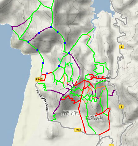
This is part of a series of pages on walking the hills of Penang. Click here for the index. This is a Grade 4 walk. There is a sketch map at the bottom showing the route followed. Please visit my Penang buses page for information on accessing the starting point, but to be honest the timings do not work well! The number of official paths in Penang's National Park is quite limited and, with the exception of one to Bukit Batu Itam, most are overused and degraded. For reasons I can readily guess, the excellent path from the Hokkien Cemetery in Teluk Bahang to Bukit Batu Itam and on to Pantai Acheh does not officially exist. However, old maps show more paths in the area and today these see very light traffic. Recently I have described those from Pantai Mas to Bukit Batu Itam and Tanjung Gemuruh to Bukit Batu Itam. Today's hike completes the trio of paths in this area north of Pantai Acheh village. The report below concentrates on the novel middle section with the climb. The other parts, which will be familiar to those considering this hike, have been covered in detail in the following reports:
Any serious student of hiking in Penang ought to have a copy of this set
of 1945 maps: Based on the maps, we chose to start our climb just after the split boulder before the stream with the water pipes. This is not actually the 'end of the ridge' but just after it. I did think that maybe there was a mistake in the map but on reflection, I guessed (correctly) that maybe the ridge itself was littered with boulders.
It's pretty nondescript, but at least mostly 'boulder free'. Whenever we saw one, we kept left and were rewarded when we hit the remains of a distinct path.
This slanted up the slope such that we were climbing faster then the ridge itself. There were minor blockages but nothing that couldn't be easily skirted.
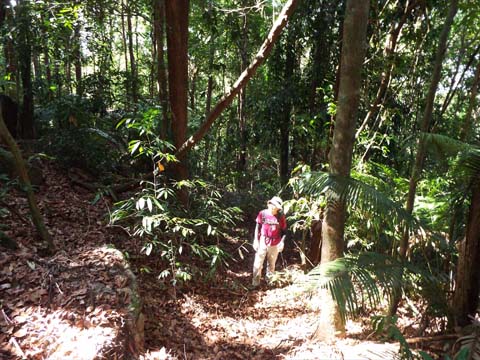
Soon we could see daylight ahead and came to the ridge itself. This was the view to the right which, if followed, would have led to an encounter with increasing numbers of boulders for anyone coming down.
Doing so, it would be extremely easy to miss the path we had used, the picture on the left shows Yuehong on the final few metres. While we had made a steady start from here on things got distinctly mixed. For the most part the ridge is quite wide and we tried to keep to the centre of it.
In Penang, flat or gently rising ridges can get colonised by these prickly monsters when large trees come down. They are usually sufficiently separated that a way can be found through them but it can be slow going. In this case once the climb eased we were never very far from them.
There were few fern patches but in fact owing to the extended dry spell there was very little 'ground cover' which must have sped up our progress. The open area may have been cleared by fire following a lightning strike, there were two very sad dried up wild boar wallows here.
There were spells where we could progress easily and just now and again we saw signs that people had been here. This small sapling had been cut.
Usually we could skirt the kind of 'rubbish' shown below, at other times we used our sticks to clear it, maybe not quite as difficult as the pictures might suggest.
We reached a minor summit and as the map had suggested we needed to continue slightly to the right in an area where the trees at last dominated. There was very little climbing left to do.
We got the impression there was more 'traffic' here because not only was the path more apparent, for the first time we could see obvious diversions round blockages.
This was a sure sign we were approaching journey's end. The brightness would be because ahead was the main ridge running across us south from Bukit Batu Itam and suddenly we stepped out onto the familiar comparatively well used trail. There was no obvious junction and we must have rushed past this point many times without appreciating that the ridges joined here. If you want to do this walk in reverse, you'll need very sharp eyes or more likely a GPS to find it. It's not on our 'to do list', while it had been very satisfying to rediscover the old path, it is unlikely to ever get busy enough to keep it clear.
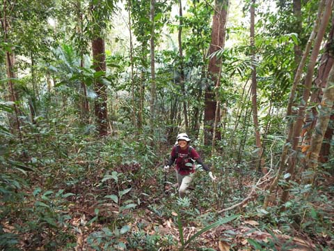
I took one last picture of Yuehong racing downhill, we had been out barely three hours after all, and then I put the camera away. We were starting nearly half way down the descent from BBI to Rain Gauge 25 (RG 25) and this meant that the Tiger was barely an hour away. Normally I go on ahead but today I was limping, I thought my boots were getting old but it turned out that I had a small thorn which had got under my toe.
It's the fifth time we have come down this way this visit, it's far more 'knee friendly' than the paths to the north and we much prefer the relaxed atmosphere in Pantai Acheh compared to the relative bustle of Teluk Bahang. As for this refound route, I suspect that there are only one or two people who might now follow in our today's footsteps.
|