|
Penang Hills and Trails - Tanjung Gemuruh Explorer |
|||||||||||||||||||||||||
|
This is part of a series of pages on walking the hills of Penang. Click here for the index. This is a Grade 4 walk. There is a sketch map at the bottom showing the route followed. Please visit my Penang buses page for information on accessing the starting point, but to be honest the timings do not work well! Forest Ang's classic book 'Nature Trails of Penang' Island describes a hike to Pantai Mas with a descent from Bukit Batu Itam which includes a reference to a junction where the reader should turn right. Today's hike followed this other path upwards to this point as it climbs along a ridge arising from Tanjung Gemuruh between Pantai Acheh and Pantai Mas. It was a real pleasure to find a 'new' path in the National Park in 2020. The report below concentrates on the novel middle section with the climb. The other parts, which will be familiar to those considering this hike, have been covered in detail in the following reports:
Any serious student of hiking in Penang ought to have a copy of this set
of 1945 maps: Buoyed by our ascent of Bukit Pulau Betong on a novel route we took the now familiar route past the pig farm in Pantai Acheh. Although we had not previously filed reports this was our 5th visit this season and Yuehong confidently took the lead.
We wanted to follow the ridge above Tanjung Gemuruh after crossing the stream. A GPS reading might have been a guide but as it happens there were two large boulders marking the spot. Today's guest Rexy had a close look at one of them and then Yuehong vanished upwards through encouragingly open countryside.
Mostly it was plain sailing but now and again we had to divert, albeit there was no problem as the ridge here was quite wide. Unlike the route up from Pantai Mas there was no paint or plastic to be seen and the only signs of previous human presence were some prickly ferns cut by a parang and this small tree stump.
As they say 'parts of it were excellent' and in no time we found the gradient easing, this small boulder marking the transition.
Was it a trail / path? We would answer with a resounding 'Yes' although nature was not always in agreement.
I wouldn't like to speculate on the fate of the average National Park employee dumped here with just a bottle of water, but we were all very comfortable even if the number of trees down was mounting.
Yuehong and I had reached this ridge path on a day when an intended repeat of the climb from Pantai Mas had turned into an ad hoc 'bash' so we were totally prepared for the somewhat variable next section.
Never mind, after one more big tree down we joined the path up from Pantai Mas. It was time for a short break and a fluid top up. In deference to my age and likely joys available later, I am sticking to water these days.
The 'main path' is not completely clear at the moment, there aren't enough hikers to trample the fallen branches. We soon got to the official National Park path where our trail is indicated as 'not advised' which is not a bad idea given the lack of experience of most people who might come this way and be tempted,
So after just 3 hours we had finished the day's main challenge. Rexy suggested a little 'extra' and from the campsite at rain gauge 27 (RG 27) at the top of BBI we took a steep path down through the ferns. It was anything but 'eco-friendly' but after a 20 minute plunge I passed the camera to Rexy. The large exposed 'black rock' is steep enough to need specialist equipment to go further.
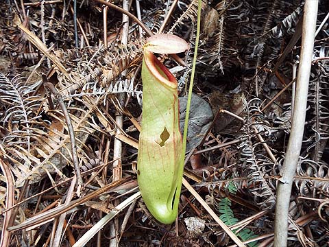
I would never describe the Teluk Bahang Dam in glowing terms but currently it is around 30% of capacity and downright unattractive, On the other hand this pitcher plant was simply delectable, Rexy never fails to spot something of botanical interest when he hikes with us.
We had left Yuehong at the top to continue back to Pantai Acheh at a sensible pace. I said goodbye to Rexy whose car was down at Teluk Bahang Market and set off, catching up with Yuehong near rain gauge 25 (RG 25). We joined the concrete path which is part of the route from near the Tropical Fruit Farm for the 'wind down section'. Unfortunately, despite a succession of promises, the 'Ultimate Trails of Penang' have still failed to clear their markers from their October 2019 event (a mere 4 months is surely enough?) and this sign simply confirms that theirs is the 'Wrong Way' to manage things. Both UTOP and the Rain Forest Hash have shown utter disrespect for the environment they operate in and the time has surely come for the various authorities to refuse them permission to continue to take people's money to despoil Penang's most beautiful areas.
|