|
Penang Hills and Trails - Bukit Elvira West
2019 |
|||||||||||||||||||||||||||||||||||||||||||||||||||||||||||||||
|
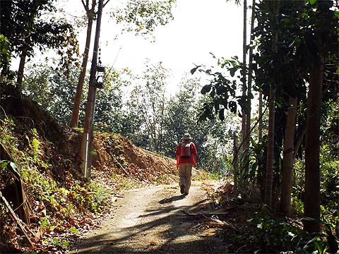
This is one of a series of pages on walking the hills of Penang, click here for the index. This is a long Grade 3 walk. There is a sketch map at the bottom showing the route followed. Please visit my Penang buses page for information on accessing the starting point. Yuehong has made astonishing progress since we started our 2018/9 hiking season in Penang. Her arthritic right knee has stood up far better than we hoped, probably because her leg muscles are compensating for the weakness (like they have for my left knee for many years) and this has allowed us to range further as the trip has gone on. Not only has her stamina improved, so has her speed which has resulted in our completing walks much more quickly, a handy bonus. We have a week of harder than average hikes coming up and this walk was designed as a 'dress rehearsal', going up the Bukit Elvira Pass on the 'Road to Nowhere' from the Balik Pulau side, but this time turning left (instead of right) when we reached the 5 way junction (Iron Cross) I won't repeat my thoughts on Botanica CT but I will add that they recently announced the start of their long promised next phase with a drive through KFC and Starbucks coupled with a full sized 'hypermarket' (ca 8,000 sq m floor space) at a time when their urban rivals like Tesco are reducing their floor space to ca 6,000 sq m; anyway, once again we had to hold our noses as we drove up to our starting point above it. This gave us a flying start of at least 50 metres in height and ensured we were not immediately baked. When we came to the main junction we swung right and headed for Jalan Chai and Balik Pulau. If you spotted that Yuehong was stickless today, award yourself a Brownie Point, with neither dogs nor scrambling in quantity, they would only have got in the way as she strode along.
This is a great route, running along the side of the hill much like the Pondok Upeh Cycleway not far away. We found a giant spider lying in ambush.
Of course, we weren't going down to Jalan Chai, we turned left and followed the 'BI' electricity poles, someone had inserted a handy short cut at the junction. We then had a gentle climb, there was a following breeze which kept us cool.
In almost no time we came to the junction with the road up from the Catholic Cemetery in Balik Pulau. We turned left and had a bit of a climb to start with but much of this section is near horizontal rubber.
We were concerned that we might find the owners of this house at home but there was no one here. We let ourselves through the gate and turned left up this path which then curved right along the top of their orchard.
Where the path passed into the old rubber, it seemed it had recently been given a makeover but this only went as far as the shelter off to the right. Almost immediately after we turned right and dropped down a couple of metres.
From here we more or less followed the water pipes across the treeless area where the path was less than conspicuous. On the far side, we turned left and fund the path again and went right till we went past the large water barrel.
From here, the pipes follow an old rubber terrace, there is a small landslide and some small trees are down, but we had cleared the worst of the obstructions on a previous visit. The valley is initially some way below the path but when it gets closer it's time to turn right, drop no more than a couple of terraces and cross through the ginger. There's then a climb of a couple of metres to a terrace which is on the same level as a hut which is currently hidden by gingers, but that doesn't matter as you don't have to go that far.
Instead, we turned left and climbed the steps, taking advantage of the clearance work we did a month or so ago. As it's the dry season now, there was no chance that it would have regrown in the meantime.
At the top we found the 'Road to Nowhere' which we followed up the hill.
Without her sticks, Yuehong was at a loss for something to do with her hands, especially as the former slippery surface was now bone dry and 'true'. In no time we crossed the chain by the shrine and entered the 'rain forest'.
We've been up the principal Bukit Elvira peak to the right but fancy having a go at the other one to the left some time, the obvious route is from this point, it's guarded by this sign which has fallen off a tree. We understand that we might have to negotiate a lot of prickly ferns to get to the summit but in theory there's less than 100 metres in height to be gained. The road then climbs away to the right.
It seems to have been an extension of the ridge trail to Bukit Elvira and soon flattens out. Once it again starts to follow the ridge it undulates and there are some fabulous large trees. Yuehong's enthusiasm allied to a telephoto effect suggests she would love to hug one.
We made it to the 5 way junction ('Iron Cross') and it was time for my traditional refreshment, it had taken just 2¼ hours rather less than the previous time we came up. We found two Chinese walkers here, preparing to turn round and return to the Air Itam Dam. The one with the shirt on was a mere 79 years old, I'll be very happy if I'm back here when I am that age.
We went left in the general direction of Titi Kerawang, we kept left at the main junction. As the sign indicates, the Da Ba Gong temple lies to the right, the location for regular Hakka feasts - email me for the date of the next one (assuming I am on the island when you read this).
We had now left all trace of the rain forest behind, this area is best described as generally low quality farmland and would best be left to revert to its natural state. The hill to the left is 'the other Bukit Elvira and to the left of it is the col where we saw the fallen forest reserve sign. The gingers are always opportunistic and here they provide some minimal shade.
There's a gentle climb to the upper area of the Sungai Air Puteh valley. As we discovered recently, the road and the orchards behind the barrier have been abandoned and for the time being, I would not advise anyone to go down here unless they have company and everyone carries a machete and is prepared to wield it. The way out at the bottom took us over an hour to hack our way through. Instead, we went down the concrete path which we knew was a viable option from the same outing.
This was our target across the valley, we could have continued along the top and turned left down the concrete road at the top of the picture, but this was 'more fun'. First we went down through the young rubber, naturally it wasn't being tapped at the moment but it wasn't tapped before the rains finished either.
This was the scene at the bottom. A year ago, passion fruit was grown here, not that it mattered today as we turned right and did our best to follow what had been a tapper's trail down towards the stream.
Having been here twice before gave us a distinct advantage and we knew there was a gap in the greenery to access the stream. Without a stick, Yuehong put her gloves on in case she had to grab some vegetation.
This was the final view down and it took only a couple of minutes for both of us to cross.
Yuehong is still more careful than I am but she was quite happy with her performance and came up smiling.
It didn't last long. The next section was largely cleared ginger with plenty of open space. As I was photographing the flower, she somehow managed to walk into one of the few remaining stalks which did its best to insert itself in her throat. In some pain, she mumbled something about contact lenses being useless close up. By the time we passed the gardener / caretaker and his lady she was restored. He had seen us going in the opposite direction and was amazed then to see us vanish, I guess he realised we hadn't been hiding in the stream for a month...
We walked up to the gate which we had skipped around last time only to find that route blocked with barbed wire. Given that it was intended to stop people like us getting in rather than getting out, it was no real surprise when we heard a motorbike coming up behind us with our friend armed with the key.
I am sure we would have solved the issue as it's not that unusual an occurrence but it was a nice gesture. It was time for another break, we remembered this swing chair from our first visit here nearly five years ago. At the time, the area around it had been cut back and there was a marvellous view.
That path to the right has always been a dead end, there was no time to confirm it again today. Yuehong marched on round the bend, the Penang Rain Forest Hash Challenge had been along here a month and a bit ago, no doubt they had effected some clearance through simple weight of numbers.
This area has been abandoned now, the shrines and big boulders are bare, although the concrete building next to Yuehong was actually a toilet which is now open to the elements. The path onwards slopes down gently but it has been completely blocked by a combination of landslides and fallen trees. Instead we (and the Hash) had to follow a rubber terrace which meant that there was an increasing gap between us and the path.
When we had come up in the aftermath of the Hash event, we had faced something of a scramble but in the intervening period some ropes had mysteriously appeared. Maybe there has been another hash run up here since although there is no paper. Whatever, the reason, I hope this kind gesture will help keep the path open - we'll certainly be back up here soon.
The final stretch of the path is completely clear and joins a concrete path through an orchard, the outstanding feature being this concrete bridge replacing the original lost at the end of 2017.
It's impossible to get lost from here, the concrete path becomes a road which curves down past the first junction shown above and so back to Mavis.
It had been an uneventful 'yomp' designed to test our fitness and we had covered over 11km in less than 4½ hours (net), with some 600 metres in height gained (and subsequently lost). We have far tougher tests ahead this week.
|