|
Penang Hills and Trails - Challenging Times,
Part 2a |
|||||||||||||||||||||||||||||||||||||||||||||||||||||||||||||||||||||
|
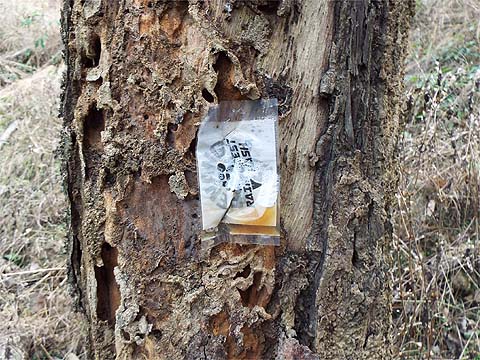
This is one of a series of pages on walking the hills of Penang, click here for the index. This is a Grade 4 walk. There is a sketch map at the bottom showing the route followed. Please visit my Penang buses page for information on accessing the starting point. We revisited in December 2019, at which time the obstructed path described below was further blocked at the lower end. We got through, but it was only possible with our considerable experience and knowledge of this path. Please be very careful if you come this way again before the assumed next Rain Forest Hash Challenge in December 2020. The two pictures below sum up our experience (2nd December 2019).
Back in December 2012, on our first ever walk from the Air Itam Dam to Titi Kerawang, we bumped into two groups of people who were 'sweeping' at the back of the 28 km 3rd Rainforest Hash Challenge, a distance which would amount to three or four of our hikes these days. A few days later, out of curiosity, we followed the start of their route out of Balik Pulau which at the time proved enough to dissuade us from attempting to complete it... In the intervening years, without really trying we have filled in much of the rest. However, what we have noticed was that their 'hares' had used non-biodegradable markers (paint and plastic) which were still visible in the jungle 4 or more years later as a result of which I sent the organisers an email (reproduced below) and I was given a welcome assurance that this time there would be a 'clean up'. They did most of it but quietly forgot to do the section between Titi Kerawang and Bukit Laksamana presumably hoping that no one would notice as this is a little used path.
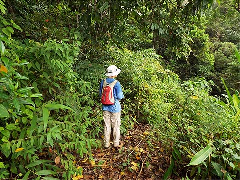
Other reports on sections of the Penang Rainforest Hash Challenge 2018 are available: Now Yuehong is probably fitter than I am, we can go more or less anywhere as long as we limit the distance covered and on Saturday, the day of the event, we had checked out the next section as far as the Air Puteh valley. On the Monday, we had done the section above Titi Kerawang and now, on the Tuesday, we would go up the Air Puteh valley itself. We were totally familiar with the anticipated route but nearly a year ago we had found the first part overgrown and suffering from fallen trees and we rather hoped the hash would have made it easier for a return visit as there is a path here which we have never used... Sometimes bad dreams do come true, as housing goes the current occupied development at Botanica is a lot better than most in Penang, it's just in the wrong part of the island. 'Attractions' like these have been promoted since before we started walking here 5 years ago and so far even the modest row of shop houses are nearly all shuttered, these billboards have appeared more recently, but don't hold your breath if you are a Starbucks or KFC fan in this part of the world. This is an 'Asian soon' indicating some indefinite time in the future or maybe not at all.
The developers have 'finished' maybe a dozen large houses at the top, but even the two show houses are not connected to the potholed road that runs past them and the rest of the development looks abandoned. Beyond and unadvertised you enter the old Penang and we parked in the middle of a durian orchard. Walking up to the T-junction we found a welcoming hash sign, it seems Mr. DIY has had a special offer on red spray paint. We'd been here a few weeks earlier on a warm up walk from Jalan Chai and it was here then.
The clearance on the left has been an eyesore since we started hiking here, at long last the scar has been concreted over which should stabilise it, whoever was responsible had the same illusions of grandeur as the Botanica developers, my rule of thumb is that it should take no more than 2 years from initial clearance to visible signs of healthy growth of young durian trees. We kept left following the red paint, there being no plastic sleeved paper left after an assumed and welcome clean up. The road becomes a wide path after this house.
For some reason, some of the plastic sleeved paper left by the run surveyors remained, it's not there now... We love the 'balancing boulder'.
Even without the paint, no one was going to get lost on this section, since last year a much needed concrete bridge has been put in across the site of a landslide which occurred in the Great Storm of November 2017.
This maintains access to the upper orchards, but where they finish, nature had been taking over. The first fallen trees had been cut.
We could now take advantage of the clearing effects of hundreds of runners but we soon came to the next obstruction.
A way had been created underneath but there must have been quite a queue here at times on Saturday! We got up to speed again...
... but when I turned around from the last picture, this is what I saw. This had been our nemesis last year and it was still in place. Only this time, there was a clear route available around it. I went up and Yuehong who has shorter arms than me pondered her next move.
It's old rubber, of course, and we had to scramble up a couple of terraces again past a welcome sign from the THK ('The Hash Kakis').
We followed one terrace and eventually rejoined the path which had sloped up more gently. This was one of two abandoned water bottles which we recovered, even one is too many but a mountain biker event would have seen rather more.
It probably would have seemed a good idea at the time, but the joke will have worn a bit thin long before the paint fades away and flakes off. 'PSC' I assume declares that the Penang Sport Club chapter were at least part responsible, I bet they would be unpopular if they decorated their home territory similarly.
Generally though, the path was pretty clean. The only red and white plastic we saw was what was left after a long strip was torn off the tree. On the ground all we saw were traces of paper which wouldn't have been enough to follow.
This paint, however, will soon be gone. When we came to the concrete road, it was time to say goodbye to the PRH challenge at least for the time being. Today's section qualified for an A in my book, only the residual survey plastic sleeves and the overenthusiastic paint work left something to be desired. Their route would continue some 500 metres up the hill before going through the rubber to where we had picked it up on Monday,
Since we had last turned right here, gates had appeared but it was easy to go round them. The track had matured but not much else had changed and the vegetation was under control.
A resident gardener / caretaker had been installed, as we walked past he appeared and, trying to be helpful, he indicated there was no way through ahead. Equally politely, having no common language, we indicated otherwise and he watched us go in blank amazement. Of course we had been here before and knew there was a point to cross the stream below the bananas.
The last couple of metres needed a little care and then it was a matter of stepping across and a short climb.
The rubber tappers were obviously coming here at least occasionally, but ahead what had been a passion fruit 'farm' was overgrown and abandoned. Fortunately we weren't planning to go that way this time.
We climbed round and came to the entrance to the overgrown area, but there as expected was our concrete path which we would follow for the first time.
We had a fair idea what to expect and weren't disappointed, we could see back to where we had come down from the concrete road.
At the top is the wide road which connects the Titi Kerawang area with the 5 way junction (the 'Iron Cross') and on to the Air Itam Dam. At this point we could have turned left and rejoined the hash route but downwards, but it would be more interesting to turn right and then right again down the now gated road.
It was clearly 'out of use' and some way down, Yuehong spotted something that persuaded us to try the road to the left which turned out to follow the contour round the hill.
As we came to the end of the orchard there was a junction, but both up and down were totally overgrown, I doubt either will ever have gone any distance, I think Peter van der Lans has been here and come to the same conclusion.
This is what Yuehong had spotted, the red arrow is a presumed PRH challenge survey marker and there were other red splashes around, including the small 'Datuk Merah' shrine where we had our lunch break. A small sign commemorates its erection in 2009 but no one has been here for quite a while and the dogs and caretakers in the house behind have all disappeared. The survey must have been unsuccessful... The decline of these orchards has been rapid and so complete that we saw a couple of monkeys here.
A year ago, we could make unhindered progress down the sealed road, now the secateurs had to come out, it did not bode well for the bottom 'dirt only' section.
The water barrel at the transition point was almost completely hidden and we ploughed on. We had only to reach the taller trees in the background, the alternative would have been to go all the way back up to the top. We don't accept defeat easily when the problem is limited and well defined. We knew that underneath that lot there was a landslide and that meant cutting a route up and down around it. Cameras and secateurs don't mix, I had lost one of the latter in Gertak Sanggul a few days earlier and the former went away.
We took our time, resisting the temptation to do the bare minimum so we might come back later in the trip should we so desire and it took the best part of an hour before we got to the trees and turned right on to what was expected to be a fairly clear section and so it was. Of course, if we had not known the route well, we would have gone back!
All that was needed now was some light snipping, in fact we could have brushed our way through and with another natural left turn we were soon at the open flat area, with the stream roaring below us to the right.
My notes said words to the effect "Go up to the twin rocks and there is a path down on the other side" and so it was albeit not well used.
Soon we could see our outward path below us and then it was just a matter of a gentle stroll back to base.
The durian orchard on the left was having its off season 'hair cut' which revealed the original rubber terraces. My records show that this area was cleared of useless abandoned rubber just three years ago (it looked dreadful then) and there are now strong young durian trees present which are bushy and around two metres high. Here at least, an owner knows how to do it and has pushed through an initial investment to a point where some return is on the horizon.
This completes our survey of the the first part of the PRH Challenge 2018 route from Balik Pulau to the Titi Kerawang valley and as you will have gathered, on the assumption that the part of the route on Bukit Elvira has since been cleaned up, I am most impressed. I hope that lessons have been learned and next time we shall see some restraint with the paint spraying (which was done before I raised the issue). Other outdoor event organisers, especially for mountain bikers, please note and take the necessary steps. The rest of the assumed route to Teluk Bahang will presumably have involved going over Bukit Laksamana, which I have covered elsewhere in a number of postings, Back Door to Laksamana, Titi Kerawang Express, Bukit Laksamana Revisited and Rimba Ridge among others. These are effectively off limits for us now as the downhill sections would put too much strain on Yuehong's bad knee although we shall probably have a look at the section up from the Titi Kerawang stream as far as the forest, which incidentally will have been the first point where the challenge encountered in quantity true 'Rain Forest'!
|