|
Penang Hills and Trails - Botanical Gardens to
The Crag |
|||||||||||||||||||||||||||||||||||||||
|
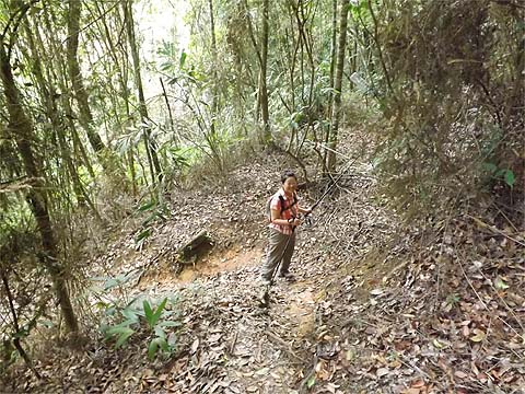
This is one of a series of pages on walking the hills of Penang, click here for the index. This is a long Grade 3 walk. There is a sketch map at the bottom showing the route followed. Click here for a list of the known PBA rain gauges. Please visit my Penang buses page for information on accessing the starting point. Just over four years ago, Yuehong and I set out on a voyage of discovery in the hills of Penang. Given our ages and then fitness, for the first three years we concentrated on the southern half of the island where the hills are less high and there are numerous paths. Historically, most of it, with the exception of a few small forest reserves was used for plantations. Today, there is still some rubber while most of the 'farming' consists of fruit orchards. Elsewhere, large tracts of land which appear to be jungle from a distance are, in fact, abandoned rubber plantations as evidenced by terracing and the occasional tapping of trees way past their prime. Sadly, some areas are now given over to flower and vegetable gardens which are an ecological disaster and also cause regular flooding during periods of heavy rain. Last year, I felt able to start checking out the trails in the north of the island. These are much fewer in number which, as such, makes for much longer walks where the only alternative to a long day is to retrace your steps. This year, I am pleased to say, Yuehong has been able to join me and in the last three months, we had covered just about every known one. Taken together with some final explorations down south, we had reached the stage where we could confidently say that we had travelled every significant trail on the island with one exception, namely that between rain gauge 9 (RG 9) and the former Crag Hotel. Today's walk was planned to put that one on our list too. Unfortunately, we picked the wrong day for it (or any other walk for that matter), we suffered camera failure and we have subsequently revisited albeit using a more user friendly ascent to rain gauge 9 (RG 9).. Yuehong 'needed' rain gauges 3 and 4 (RG 3 and RG 4) for her collection so this dictated starting in the Botanical Gardens. Despite its relative proximity to home and being served by the 10 bus, the service is anything but frequent and we walked from the Burma Road traffic lights on Jalan Gottlieb without being passed by one. So on a very humid morning we were already a little sticky when we went to the lily ponds next to the orchid house. The alternative direct ascent by the 1251 steps on the other side is an exercise is masochism we have done once and will never repeat. There is a small gap in the vegetation as shown and the trail was littered with the residue of several recent hash runs from different groups. First though, it's time to play 'Spot the Difference', 7 years and 20 kg separating the two pictures.
After crossing a stream, the climb is steep and unrelenting. As I have said on many occasions, it is crazy to set up paths which rely on ropes if they are going to be heavily used because it will only lead to their rapidly becoming degraded and this is no exception. Next time, I'll look for an alternative. At the top we turned left. Right would lead to Bukit Olivia where there was once Raffles' house but of it there is now almost no trace beyond a few extra stones and a hole in the ground.
Almost immediately the path joins the wide trail that winds up from Fettes Park. This continues for some way and is an opportunity for tired muscles to recover. Eventually if finishes in an open area and a smaller path continues. The whole area to the right was once rubber and drops quite steeply away although we saw one trail off which is presumably used by the hash.
We started to climb again and at one point there was a ruined concrete tank to the right and after it some stone steps up and down and more stones in between, presumably the remains of a small house. The sign heralds the point where the main ascent starts and a path goes left back down to rain gauge 2 (RG 2), the steps and the Botanical Gardens. The small metal signs erected by LYK seem to have vanished since we were here in 2012.
We were in 'plod' mode, it had taken us 90 minutes to get here, maybe 30 minutes longer than the direct route via the steps. Writing some time ago Forest Ang said "Lining the trail on both sides are overgrown Gleichenia ferns. The track is heavily eroded." The passage of time has not improved it. Not far above the sign are the remains of a trail going straight ahead, there is a piece of plastic stretched across to discourage its use, instead we climbed up to the right. All the way up this route as far as Western Hill are the original marker stones indicating that it has been here a very long time. Often they are marked with 'M' (Mike Gibby suggests it may be for Moniot). Quite soon we got to rain gauge 3 (RG 3).
Ferns prosper where the level of nutrients is low and on the edge of such areas, you often find pitcher plants which get theirs from the insects they trap and decompose. Again we were soon at rain gauge 4 (RG 4), probably these are the closest two of any on the island, although RG 6 and RG 7 on the summit road must run them close.
From here, the quality of the path is greatly improved as the gradient eases somewhat. The next landmark is the junction where the path comes in from the Haunted House. Although that route too has its issues, it is less used than the one we came up and we consider it a preferred approach, especially as in our case the back of Tanjung Bunga is more accessible than the Botanical Gardens.
Now in my humble opinion the next section rivals any on the island for its attractive walking. It was a total pleasure until we reached rain gauge 9 (RG 9) some 3 hours after we had left the Botanical Gardens. Forest Ang's book, using the steps, quotes just 2 hours which would be quite accurate for anyone less than 50.
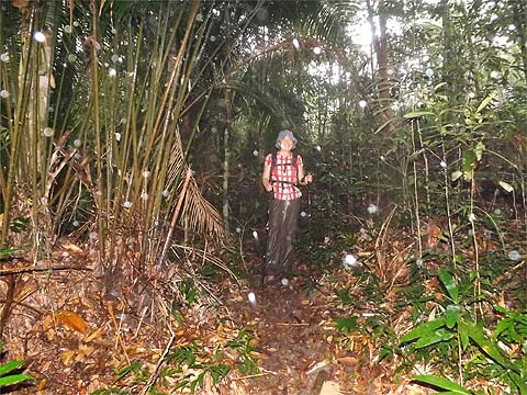
It was time for a break, unfortunately it was cut short by the arrival of the rain which was sufficiently heavy to immediately pierce the nearby canopy. We had no choice but to continue. In the interests of accurate recording, I tried to use the camera to record our experience. It was so gloomy that I had to have recourse to flash, the white dots are, of course, rain drops.
Perhaps not surprisingly, the camera took exception to this and even though I had put it in my bag, the next time I switched it on, it complained bitterly and the lens froze at full zoom looking like it had taken one too many blue pills. (24 hours later it dried out sufficiently that it lost its 'erection' but still showed no signs of wanting to consider taking photographs. After 48 hours it had almost returned to normal, and after 72 hours it was fully restored, something that would not have been the case with an old fashioned 'film' camera as I discovered in 1976 when I dropped one in a padi field in Java.) So you will have to take my word for what follows. The path down is definitely in a better state than Forest Ang describes it in his book 'Nature Trails of Penang Island' and there is no chance to lose it. The boulders at the bottom are, naturally, still there bridging the stream. Going up, too, it would need a big effort to get lost. Unfortunately, nothing can change what he describes as 'an almost vertical ascent', challenging at the best of times, it was doubly so when we were soaked to the skin. We got to the drain that runs around the former Crag Hotel, turned right and where it was blocked by a boulder clambered up a few metres to emerge with the main building to our left. A few years back, it was tarted up for the filming of 'Indian Summers' which was what some call a 'docudrama', a period piece in which it was somehow transformed into the Royal Simla Club in pre-independence British India. I have been told that it was quite enjoyable for those totally ignorant of that place and time. In a sensible world, that would have been a cue to spend a bit of money to renovate it properly and market is as a nostalgic boutique hotel. It was now 16.00 and we had to get down somehow. If I had known it was going to start raining again at 17.00 and continue for at least 5 hours then we would have taken the train. However, it's overpriced for non-Malaysians and it was still some way uphill, So we took the jeep road, which is a knee wrecker as far as I am concerned, turning off at '84' to go down the path to the Hye Keat estate. By the time we reached the bottom, Yuehong was going faster than I was. We allowed some of the water to drip off in a hawker centre by the Hill Railway Road roundabout. Fed and watered internally, we froze in the 502 and 101 buses and finally got home at 22.00. It was not perhaps the 'happy ending' we would have hoped for our explorations but as I wrote this report later, while the sun shone constantly, it seemed like one of life's little hiccups. Why 'Part 1'? Later we had to go to RG 9 again and record the final section, at least we knew exactly what we were letting ourselves in for. The bonus for me was starting a lot earlier and getting to as yet unvisited RG 7 which is off Summit Road some way towards Tiger Hill. We also then took the opportunity to have a look around The Crag as it exists today.
Of course, we aren't going to hang up our walking sticks but any future voyages of discovery will probably be 'pathless' or on routes where a path has long ago perished. Most of our hikes will be like meeting old friends after a long time, as happened last Wednesday when three of us who worked together at USM 40 years ago met up again, the others are Roger Jewsbury and Penangite Sam Teng Wah.
|